
General Trail Thoughts:
Remember that quote from the last post about expectations? Well, for some reason I expected the climb to be a little easier than it should be. I guess gravity doesn’t care much about my “hiker legs” since uphill is still uphill. Hiker legs is a term that essentially refers to when we are well conditioned and don’t need as many breaks as we did at the beginning of the hike. I track my walking pace with a Garmin Phenix 8 watch (bought on sale, thanks REI). When I started, speeds were 24 to 30 minutes per mile on steeper terrain. The day I did a 19 mile day averaging 20 minutes per mile, I was excited. Now I can accelerate to 3 mph and be satisfied that everything is fine. I use my watch because I find that when I’m not looking at it I tend to get distracted easily, which is no surprise to Marnie, I’m sure. There are many great places to see and pools to look for fish and have fun, believe me.
Day 42
19 miles or so
From mile marker 703 elev 6006
Two mile marker 722 student 9162
Approximate rise 4275 Fall 1348
Camping: Bill, Mawsha, Hana and a couple of newcomers.
People I walked with: Nick from England
I left KMS today around 10:00 am because I didn’t want to pass up Kennedy Meadow General Store’s pancake breakfast. I was walking and thinking, this is it, this is the real beginning of the Sierra Nevada mountains. Side note, did you notice that I previously switched hats to Sierra Nevada Brewing Company just for this stretch?
I stopped at the bridge over the south fork of the Kern River. There I saw a golden trout and although I wanted to fish, I knew there would be other days. However, I regret starting late because I would have started earlier and caught fish.
This bridge is over the south fork of the Kern River.
There are many different plants and flowers that I pass by. I use iNaturalist’s Seek app to identify them. I use Merlin to identify birds by their songs. Here is a cool flower that appeared in the lands of sages.
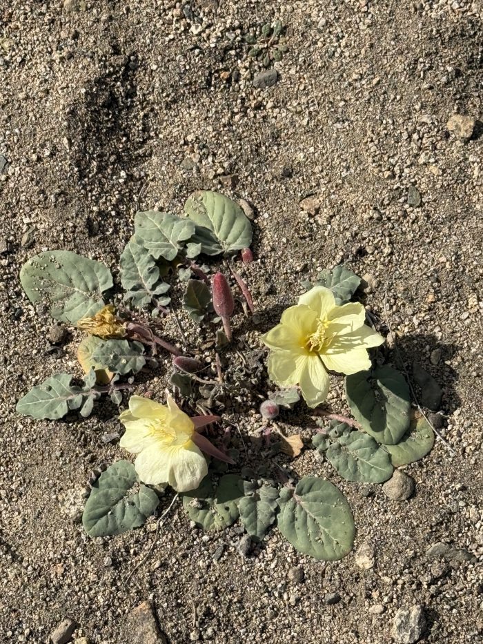
The Woody Fruit Evening Primrose (according to Seek / iNaturalist)
Tonight they brought the dreaded Sierra mosquitoes and I’m happy to report that the permethrin treatment on my hoodie seemed to work. I saw several land on my sleeve and leave. Of course that doesn’t do much for my hands, neck, face, etc. Tonight’s sunset was spectacular and is the featured photo of this post.
Day 43
24 miles or so
From mile marker 722 elev 9162
Two mile markers 744 student 9975
Approximate ascent 4020 Descent 3400
Camping: sun, zip line and Patrice
People I walked with: no one
This day was a typical day of beautiful scenery and hiking up and down. A mile after leaving my campsite I came across a larger campsite with 8 tents. Wow, it was packed with people and I can only imagine the snoring that ensued. This day was unique because I left the trail in search of water twice, once halfway along the trail and once at the end. Camping was fun and full of mosquitoes. I camped with Sunshine, a Marine who went through 9 surgeries and is here to prove to himself that he still has it. He’s fun to be with and I’m sure we’ll cross paths again. I also camped with Zip Line and Patrice, both French. After PCT Zip Line she will be leaving the US for Africa with her husband and Patrice is using last year’s vacation, this year’s vacation, and I think some credit time for the 5 months she will be taken away from her job. I mention these things because it’s great to meet people and realize that a lot of things are happening outside of our little bubbles. Every person we meet is a story to explore.
Day 44
25 miles or so
From mile marker 744 elev 9975
Two mile markers 768 student 10642
Approximate ascent 4377 Descent 3225
Today was a push to get to Crabtree Meadows in preparation for climbing Mount Whitney. I have seen Mount Whitney since I was a child taking trips with my father to my grandfather’s alfalfa farm, 20 minutes north of Bishop. Later, once I got a driver’s license, my friends and I would take epic fishing trips to the Eastern Sierras and the entire time we would drive around the highest point in the lower 48 states. This day was another fun day and I had my first real river crossing, well, stream crossing on Rock Creek. I chose a rock with a large log touching it to cross the stream.
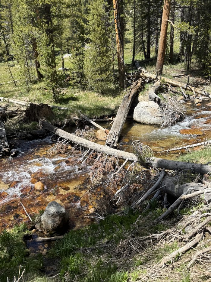
This is a typical stream crossing scenario.
There are times when a person can safely walk on a log and others when there is no choice but to get their feet wet. I prefer to keep my feet dry, but this day I had two log crossings and a rock dance to cross streams. This day also turned out to be a true Murphy’s Law day. People familiar with the Sierras know that the afternoons can be a little humid and storm clouds gather. Today was one of those days, and as I approached Crabtree Meadows, the gray clouds turned dark and ominous. I quickened my pace as thick drops of water fell and happily found myself among the approximately 30 tents scattered around. Then the few drops turned into big hail and the big hail turned into a crazy storm that in 45 minutes dropped 2 to 3 inches of hail, turning a once green meadow into a white winter scene. I have a tent that, when set up, starts with the rain fly first. Imagine my surprise (and joy) when I discovered that one pole didn’t fit! I put 3 corner poles to support the tent, but the fourth pole didn’t fit. I tried duct tape, but it was too wet and cold, so I sat under the partially pitched tent with my backpack. As I sat on my Tyvek footprint, I made dinner while it was storming outside. I also made some videos badmouthing the tent manufacturer. Actually, if this had happened the night before I would have been discouraged, but I faced it without anger. When it fails, when is it most needed? Well, some choice words were used about the failure of ultralight camping equipment. After about 45 minutes the hail subsided and I discovered the problem. I removed the insert and used a piece of Tenacious Tape to hold it in place. Problem solved and really, let’s talk about first world problems, since yes, without a properly functioning tent in the highlands there could be a problem, but really, I’m on a 5 month hike. Oh, there was a guy in a hammock with a proper rainfly on it and he was fine. Then his hammock broke in half and he was thrown to the ground. Now that’s a problem. Tomorrow is Mount Whitney!
Day 45
16 miles or so
From mile marker 768 elev 10642
Two mile markers 768 student 10642
Approximate ascent 4000 Descent 4000
Mount Whitney is something I’ve wanted to climb for a long time, but thought I wouldn’t be able to do it. I had tried to get permits when I was younger with no luck and then with a torn calf muscle I didn’t think I could do it. I really credit physical therapy, dry needling, and muscle activation technique, along with a lot of training, for this success. One of my favorite views of the mountain is from the old USFS office in Lone Pine. There you can find two tubes through which you can see the views of the 14,505′ high mountain. An upward angled tube has a label that says «Mount Whitney on a clear day» and when you look through it you see the specific peak in question. The other tube, at a slightly flatter angle, says «Mount Whitney on a cloudy day.» Well, when you look through that pipe you’re looking across the street at a mural on a building. Kudos to the boring but creative government worker who came up with that. Here are some photos from that day.
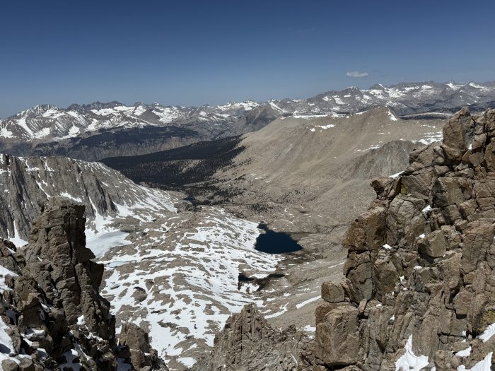
Looking towards Guitar Lake and Crabtree Meadows
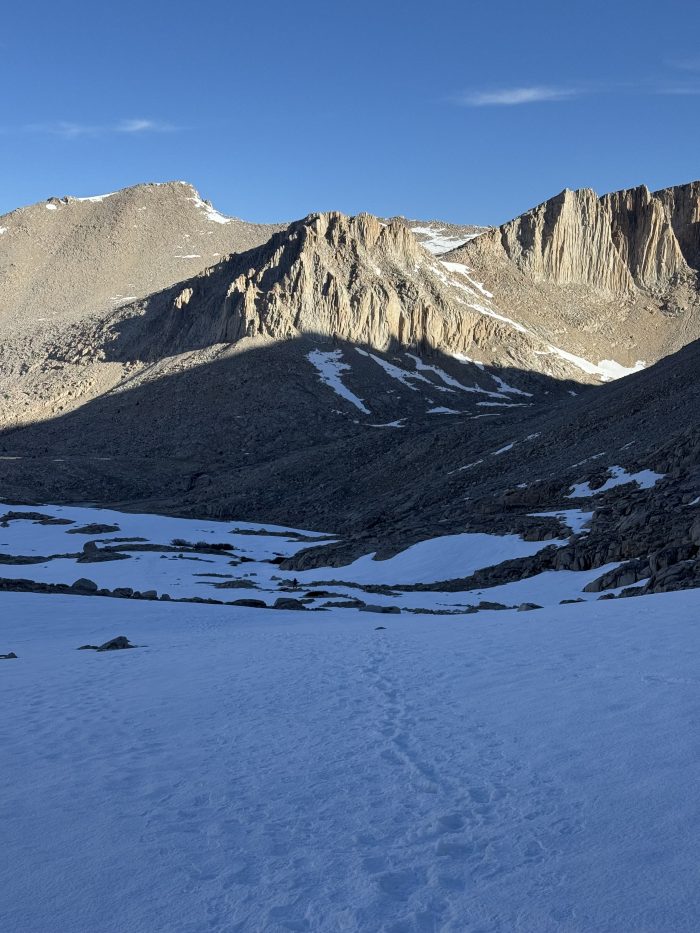
A sunrise illuminates a steep cliff with footprints in the snow.
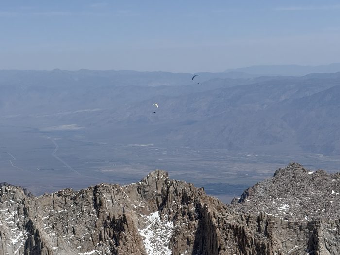
Paragliders at 13,000-14,000 feet!
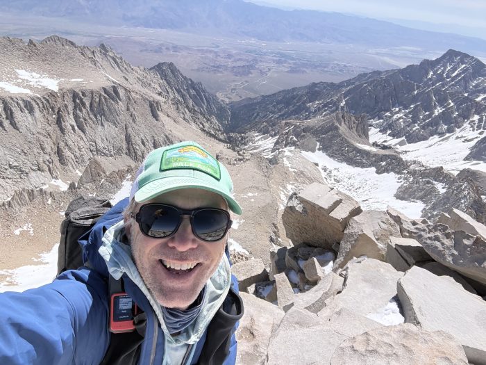
A selfie looking towards Lone Pine. One step back would have resulted in a fall of a few hundred feet.
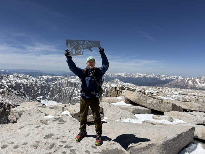
A hard-earned photo! Oh, the pride of being so high and then laughing when a crow flew overhead.
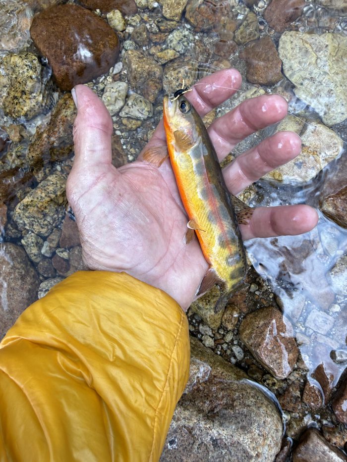
My first pure strain golden trout
The excitement of being on top of Mount Whitney was extreme. I’ve looked at it for a long time and finally accomplishing something that I thought was so out of reach gave me a confidence in myself that I hadn’t had before. That’s saying something, since I’m pretty confident in myself…
One of the funnest moments of the day was having cell service at the top of the mountain and texting a photo of me standing on the top of the mountain to my dad, who replied «be careful.» I laughed and told a guy next to me about the text and he responded, «We’re over that.» We both broke down over it. I still have a smile and a rush thinking about being up there.
Next, I’ll take 3 easy days to catch more goldfish, camp at 12,500 feet, cross California’s highest and most dangerous pass on the PCT, and then exit the PCT via Kearsarge Pass to meet Marnie in Onion Valley. Oh, the arrogance of plans.
This website contains affiliate links, which means The Trek may receive a percentage of any products or services you purchase using links in articles or advertisements. The buyer pays the same price they would otherwise pay, and their purchase helps support The Trek’s ongoing goal of bringing you quality backpacking information and advice. Thank you for your support!
For more information, visit the About page of this site.

:max_bytes(150000):strip_icc():format(jpeg)/nicholas-godejohn-061026-8ae2d424a4da4cf393ba3f116c46c927.jpg?w=238&resize=238,178&ssl=1 "Dentro de la vida de los padres de Nicholas Godejohn después de que su hijo matara a la madre de Gypsy Rose Blanchard")


:max_bytes(150000):strip_icc():format(jpeg)/nicholas-godejohn-061026-8ae2d424a4da4cf393ba3f116c46c927.jpg?w=100&resize=100,75&ssl=1 "Dentro de la vida de los padres de Nicholas Godejohn después de que su hijo matara a la madre de Gypsy Rose Blanchard")


